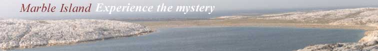
|
| |
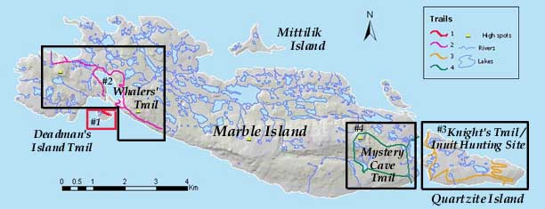
Hiking Trails |
|
Trail One: Deadman's Island
The other graves and monuments all have their stories to tell, though some of those stories remain unclear. Two whalers' graves from the winter of 1886-7 are simply numbered 15 and 16. Records indicate that these may be two men who died from exposure from the cold when they went AWOL and tried to visit their girlfriends camped at the east end of the island. The fact that the graves bear no names may be a warning from the captain about the results of such actions. There are graves for Charles Lathe, First Mate, and George Verino, a Canadian, from the whaling ship George and Mary from the winter of 1878-9. Thirty years ago a small clear glass bottle with a poem inside was found a short distance from Verino's grave. A few lines of the poem capture the timeless mood of the Island. ...My heart feels sad, for a shipmate lies low Deadman's Island was also used as a storage area. Whaling ships would unload barrels of supplies on their way into Whaler's Harbour, making passage easier through the shallow waters. When supplies were needed the barrels were broken open. The rusted rings survive. Return to Trail Map Trail Two: Winter Home of WhalersThe second trail, which circles the Whalers' Harbour for much of its length, includes fascinating geology, evidence of wildlife, artifacts from the whalers' era and reminders of some of the colourful characters and events connected to that period.
Of course it was whaling that drew so much activity to this part of the island. During the second half of the nineteenth century it was not unusual for several whaling ships to be overwintering in the harbour with Inuit camps set up nearby to trade with the whalers (and assist them with the hunt in the spring). You will see the shoreline where the ill-fated Orray Taft was beached in the fall of 1873 after damaging her stern whie entering the harbour during a gale. Bricks, barrel hoops and broken-up rusted iron remain on the shore. The wreck of the vsse; jerse;f was carried off by ice during spring breakup and now lies below the surface twenty meters from shore. On calm days at low tide she can be viewed from a tour boat. There are graves on this trail, remarkable for being on the main island and not among the graves on Deadman's Island. Like much of the history of the island, their stories are unclear. One grave appears to be the final resting place of a woman, judging by the artifacts also buried here. Whaling captain Parker records the death of a woman in one of his logbooks. Another grave apparently belongs to one of three brothers known as the Canuck Harpooners. In 1855 this harpooner met a violent end shortly after attacking an Inuit woman and was buried quickly where he fell. The grave wasn't discovered for more than twenty years. Shortly after the harpooner went missing, the whaler that had defended the Inuit woman took over his job. You will learn about Kerrigan the Harpooner, who turned down a chance to be rescued after that disastrous winter of 1873. With the help of an Inuit crew he amassed a small fortune in whale oil and furs by the time he left on a passing whaler several years later. You will see the place where an Inuit family, coming to the island to trade, may have been set adrift to drown in a leaking boat after witnessing a whaler kill another with an axe. The trail includes the stone foundation of the theatre, built for the whalers to entertain themselves in 1864. It was the site of stage productions and boxing prizefights. Return to Trail Map
Trail Three: The Knight Expedition/ Inuit Hunting Grounds
The largest onshore legacy of the Knight Expedition is the foundation for Knight's house, built with materials brought from England. A markr on the trail point to the underwater location of Knight's 80-ton frigate Albany (in the cove between Quartzite and Marble Island). Divers in the early 1990's found that their movements dispersed the silt enough for them to get a good look. With the help of sonar, the same team (Beattie's expedition) were able to locate Knight's other ship, Discovery, lying nearby. However, the poor underwater visibility prevented divers from seeing much at that time. The most mysterious aspect of Knight's legacy is the absence of a gravesite for the thirty-nine men of the expedition.
Geological points of interest include pieces of rock with imprints of the sea bottom; verdigris outcropping; and rocks resting in their own debris. Return to Trail Map Trail Four: The Mystery CaveThe main mysteries off this trail relate to a cave that once existed up on the gorge. It also includes the site of an Inuit encampment that witnessed the arrival -- and end -- of the Knight Expedition across the cove; a hidden valley; and a chimney cave. The Inuit encampment, located on the leeward south shore for protection from northwest autumn gales, includes features similar to the archaeological site on Trail #3. There are circular tent rings left by single tents and figure eight rings left by two tents pitched side by side to create one large tent. There are graves, a ceremonial circle and food caches in the form of large boulders used to keep out animals, insects and to keep the meat cool. The 'mystery cave' collapsed some time ago, leaving a porch-like overhang visible from the trail. Above the cave is a peculiar stone formation. What was the cave used for? Possibilities include a sleeping place, a hideout or a lookout. Artifacts found at the cave and displayed at a safer location on the trail are an oil lamp (kudlik), a wooden snow beater and a round wooden container the size of a tea cup, possibly European. The Hidden Valley provides unique landscapes for photographers, especially in autumn colours, and a cave-like tunnel. You can enter this 'chimney cave' in an opening at the bottom of the rock face, crawl up inside for twenty feet and climb out on top of a cliff. Return to top of page Plan Your Own AdventureNow that you've learned some of the basic facts about Marble Island's location, history, wildlife, geology and trails, it's time for you to consider a visit to this mysterious and haunting destination. Plan Your Adventure |
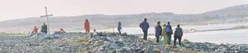 This island is named for the two dozen graves along a ridge overlooking the entance to the Whalers' Harbour on the main island. Fourteen of those buried here were from the crew of whaling ships Orray Taft and Ansel Gibbs, who died of scurvy during the winter of 1873. The graves are numbered so that a monument can identify the dead, who came from as far away as Germany and 'North Africa'. There is also a monument to the crew of the Abbie Bradford, the third whaling vessel that sought shelter on Marble Island that same winter.
 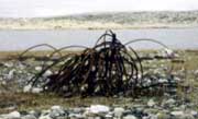 There is a large, well-built grave for a man nicknamed 'Pirsluk' by the Inuit. A rough translation would be "the one who does funny or silly things." He was also referred to as the Second Captain or mate, but of which ship is also a mystery. His grandson Papak was the first husban of Putuguk. Many direct descendants still reside in the region.
 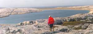 Among the geological points of interest are a sea cave, a pressure fault, a glacial moraine, erratics and a possible raised marine deposit. Along the trail your guide will show you a fox den, stickle back fish and small lake that is home to a family of swans.
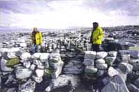 This trail circles Quartzite Island, exploring the tantalising clues to the fate of the Knight Expedition and revealing clear evidence of the island as a warm weather hunting ground for the Inuit. The trail also includes fascinating geological formations. Offshore is an opportunity for divers to explore 18th century shipwrecks.
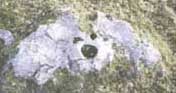 Of course Knight's time on the island was extremely brief compared to the centuries that Quartzite Island was a warm weather hunting ground for the Inuit. From the trail you can see, by looking uphill, an archaeological site (half a square kilometer) containing tent rings, food caches, a few kayak rests and burial sites. In fact it is not one large camp, but many. Each new camp was pitched closer to the water, but as the island rose slowly out of the sea, the sites of the older camps 'moved' up and away from the water. Walking up from the shore is like stepping back in time. On another part of the trail is a large area cleared of boulders to form a nice flat floor for a ceremonial circle. It would have taken a tremendous amount of skins to cover a tent this size, yet there is an entrance. Perhaps it was an outdoor recreational area used for dancing and related activities. Lush vegetation inside the circle is a clue that food was used here. Yet another mystery.